
It's been more than a week since we've returned from Machu Picchu, and my blogpost on our visit is overdue. Part of the reason is that I needed some time to process the photographs, but mostly, it is because it is so difficult to convey what it was like to visit this place.
Heads up: This is going to be a longer post, with lots of photographs!!! Also, I have included a map of the site as a reference at the end of this post.
We arrived around 9 am and luckily, the site was not yet overtaken by tourists. We got our first look at the site from the Agricultural Terraces, where visitors enter the site. The sky was overcast and the light wasn't great, but I stopped to make a few photographs. Before long, a small area started to open up in the clouds, and the sun started to light up the ruins. Grateful for the gift, I captured this panorama.

Machu Picchu - View of the Urban Section in the foreground, with Hayna Picchu in the background. The photograph is taken from the Agricultural Terraces, near the visitor's entrance. The sun had just finished lighting up the Citadel, leaving the surrounding valley and mountains in the shadows.
As much as I tried, and I am happy with the image, it still doesn't convey the beauty and the grandeur of this site, and most importantly where it sits, among the majestic Andes mountains, and so near to the clouds.
The site sits at 2430 meters above sea level (8,000 feet) and covers around 13 square kilometers. It is said to have been built in the 15th century under Pachacuti Inca Yapanqui, the 9th Inca of the dynasty. I must confess that I didn't remember much from my history lessons in school. I had only very vague notions of the Incans and the Mayans, so I had to look some things up. I was surprised to find out that the Inca dynasty only lasted just a little over two centuries, from the 13th to the early 16th century. The dynasty grew very quickly and underwent their greatest expansion under Pachacuti, to cover a large area of South America. At its peak, the Empire included Peru and Bolivia, some parts of Ecuador, a large part of Chile and even extended up to Argentina and Colombia. (see machupicchu-inca.com)
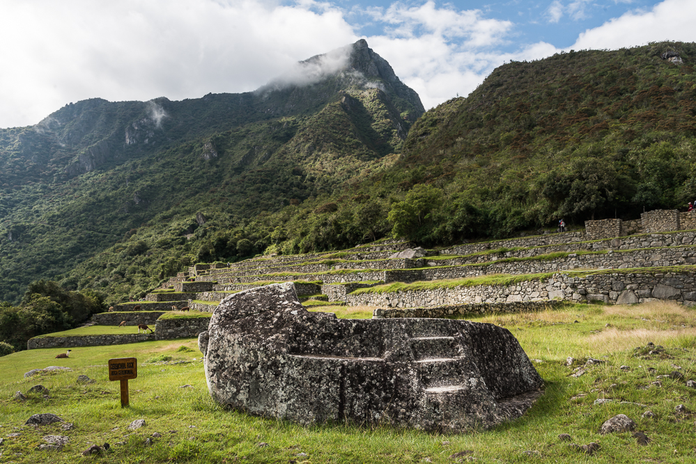
As we like to buck the trend, we took the path backwards, starting with the end. This had been advised in some blogs as a way to stay away from the large groups of tourists. This took us up to the House of the Guardians, also referred to as Watchman's Hut, with yet an even more stunning view of the site. This structure was located strategically, given the guards a view of the Urban Sector as well as the Agricultural Sector.

This view is taken from the top of the Agricultural Terraces. From here, we can see the House of the Guardians on the right, and the other side of the site can be seen. Interestingly this would have been the "front" of the city, and the only entrance to the site would have been on this side. Below, in the valley, we see the Urubamba River, which nearly circles the whole mountain.
Behind the House of the Guardians, we find the Funeral Rock, where bodies were laid to dry, prior to mummification. It appears that only the bodies of the kings were mummified. Bodies of Royal family members were buried in tombs with several valuable objects, while the common people were simply buried in the ground in simple surroundings. It is also said that the Inca practiced sacrificial offerings, both animal and humans.
Funeral Rock, with the cemetery immediately behind.

Terraces behind the House of the Guardians, and the path toward the Sun Gate Trail. Llamas are grazing on many of the terraces.
From here, we headed down into the Citadel proper. This would be the area known as the Urban Sector, where the King, the members of the Royal family, the Nobles, and the citizens would live. It is not yet known whether the Inca would reside at Machu Picchu for extended periods, or if the site served more as a retreat, perhaps for specific rituals.
Here are two views of the staircase that separates the terraces of the Agricultural Sector from the structures of the Urban Sector.

In this view, we get a good look at the part of the Urban Sector used by the Royal Family. In the lower part of the photograph, to the immediate right of the center, we see two rows of houses that would include: Nuestra's Bedroom, the Temple of the Sun, the Ritual Fountain, the Royal Tomb, and the Royal Palace. The structures in the upper section, to the left of the image, might have been where the Royal guests would have stayed.

This view, still showing the central staircase between the terraces and the Urban Sector, gives a view of the lower part of the Citadel. Here we see the section where the common people would have lived. In the forefront, we would have the Prisoner's Area, the Industrial Zone, and the Factories Area. In the background section, we can see the Sacred area of the Citadel.
The Temple of the Sun is a particularly interesting structure, with its curved wall and trapezoid windows that are said to align perfectly with the position of the sun on specific days of the year. It was used for many religious rituals and also served to create the Incan calendar. Below the Temple is a cave which displays highly refined stone work. The cave was believed to be the tomb of the King.
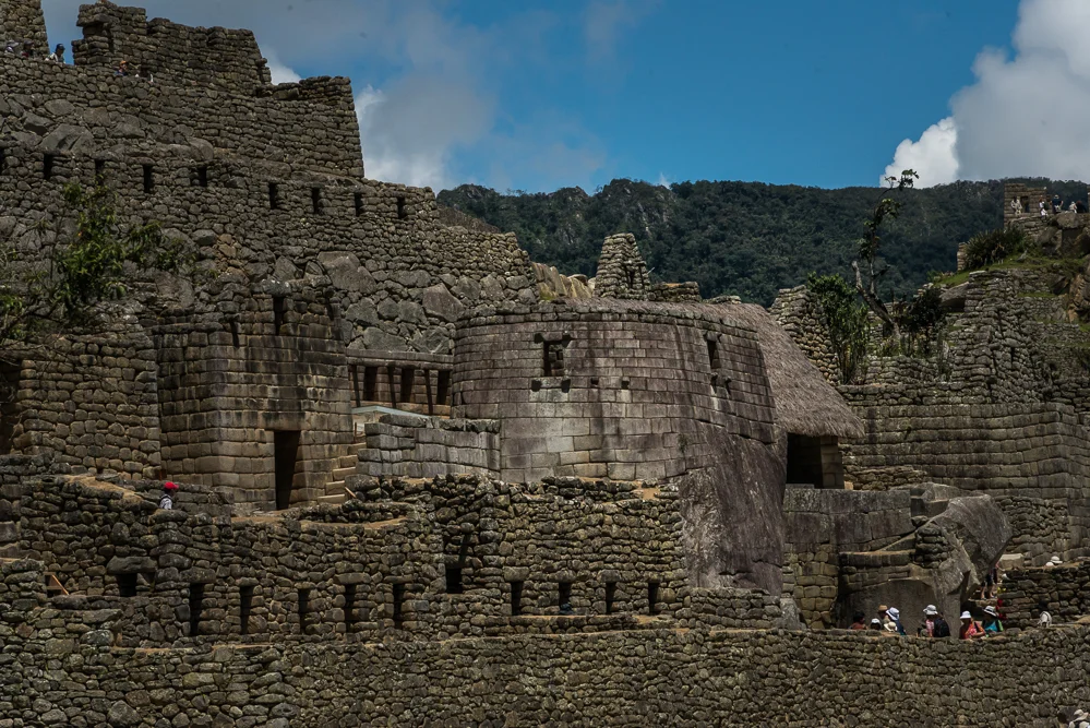
The Temple of the Sun

The Royal Tomb
From there, we made our way towards the Sacred Plaza, with the Temple of the Three Windows, the Main Temple, and Intihuatana.
The Main Temple is believed to have been the most important of the Citadel, and it would have been where most important celebrations and sacred rituals would have taken place.

The Main Temple with seven windows on the back wall, and five windows on each of the side walls. The large block at the back is believed to be an altar.
We continued to climb and reached the highest point of the Sacred Plaza, where we saw Intihuatana.

Intihuana Stone
One of Machu Picchu's primary functions was that of astronomical observatory. The Intihuatana stone (meaning 'Hitching Post of the Sun') has been shown to be a precise indicator of the date of the two equinoxes and other significant celestial periods. The Intihuatana (also called the Saywa or Sukhanka stone) is designed to hitch the sun at the two equinoxes, not at the solstice (as is stated in some tourist literature and new-age books). At midday on March 21st and September 21st, the sun stands almost directly above the pillar, creating no shadow at all. At this precise moment the sun "sits with all his might upon the pillar" and is for a moment "tied" to the rock. At these periods, the Incas held ceremonies at the stone in which they "tied the sun" to halt its northward movement in the sky. There is also an Intihuatana alignment with the December solstice (the summer solstice of the southern hemisphere), when at sunset the sun sinks behind Pumasillo (the Puma's claw), the most sacred mountain of the western Vilcabamba range, but the shrine itself is primarily equinoctial.
From: Places of Peace and Power (https://sacredsites.com/americas/peru/machu_picchu.html)
From there, we could again take a look at the Citadel and the Agricultural Sector and the view was unbelievable. The site was already becoming more crowded, and you can see groups of visitors in various locations. Fortunately for us, the sun was still shining, something that was considered a rare occurence during the rainy season.
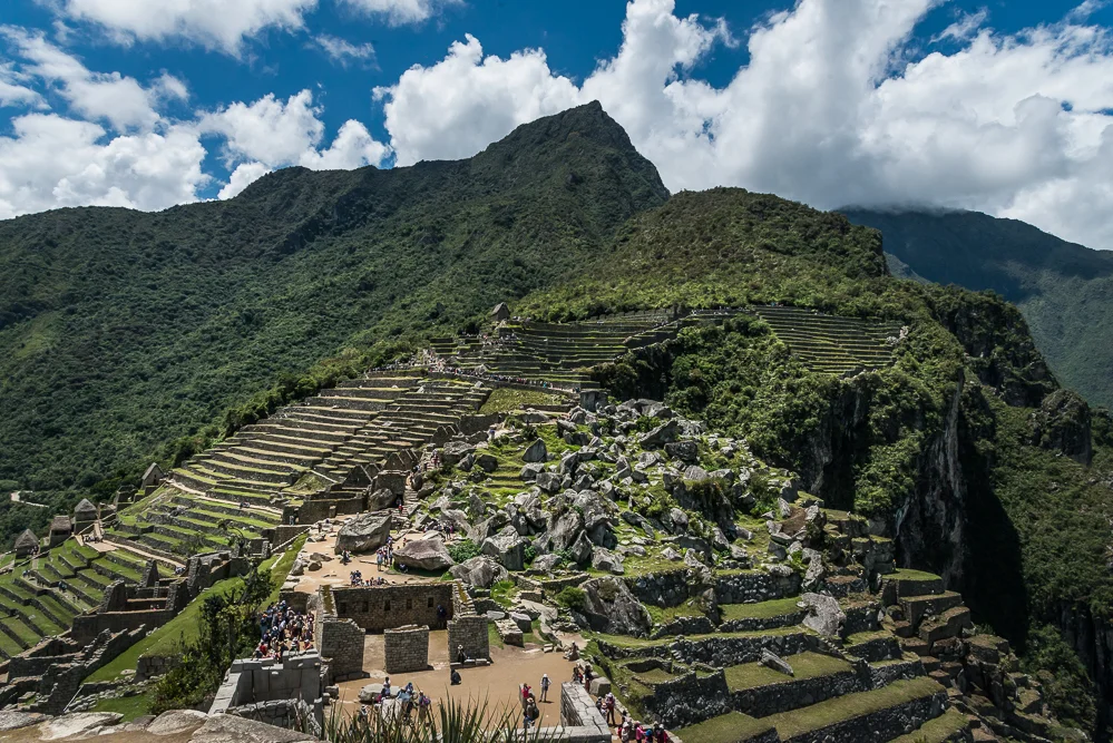
Machu Picchu, seen from the higher level of the Sacred Plaza, near the Intihuana stone. In the foreground, we see the Main Temple, below, and the upper section of the Urban Sector. To the left, we see the terraces of the Agricultural Sector, and in the center, in the distance, we see the Watchman's Hut, from where I had taken panoramic views earlier in the morning.
Looking toward the other side, we have the view of the Main Square, the Factory Sector, and Haynu Picchu. Those who are intrepid enough to make that climb will have the privilege to find the Temple of the Moon at the top. Let's just say that we chose to focus on the Citadel and we passed on that trek!
Hayna Picchu is considered to be the young peak, relative to the rest of the mountain. Its is at approximately 2,720 metres (8,920 ft) above sea level, or about 360 metres (1,180 ft) higher than Machu Picchu. The number of visitors allowed to climb Haynu Picchu is limited to 400 per day. The climb is quite challenging, with some areas of the path being exposed (to the cliff below!!!) and other sections requiring a steel cable to provide support. The path can become slippery and even more difficult during the rainy season.
So, to anyone who manageed to make it to the top: RESPECT!!!

Here is a closer look at Haynu Picchu, with two close ups on the mountain.

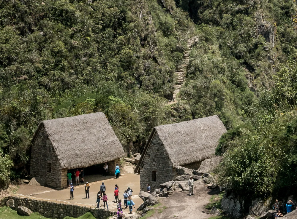
A closer view of Hayna Picchu. We can see the beginning of the path just behind the two huts, but then the path disappears and can only be seen again near the top.

In this close up of the top of Haynu Picchu, you can see the last terraces toward the end of the climb and climbers making their way up. If you look closely at the very top, you can see climbers standing there.
This is the Haynu Picchu gate, where visitors must register before heading up the path.
The construction of the Citadel is astonishing, particularly given that the Incas did not use wheels. Although they had the knowledge necessary, it was not practical for them to use the wheel. The terrain for much of the Empire required much climbing and many stairs and/or terraces were built along the hills. Goods and supplies were carried by porters or llamas. Many of the stones that were used to build the city weighed more than 50 tons. While some were chiseled from the granite bedrock of the mountain ridge, but it is said that hundreds of men would push the heavy rocks up the steep mountain side. I still find it difficult to conceive how this was possible.
The walls of terraces and many of the buildings are made of field stones that they stacked so expertly that the walls still stand after centuries. The walls were always leaning inward, which gave additional strength and stability to the structures. The construction of Temples and of living quarters for Royalty and for the Nobels used a much more sophisticated technique named 'ashlar'. The stonemasons did not use tools, but rather used harder stones and a slurry of sand and water to grind each stone so that it would fit perfectly with the stone next to it. Many of these stones are not square, instead, they take various shapes.

These structures were built with field stones.

Here, we see the distinction between the construction of the lower wall, and that of the Temple of the Sun just above.

Here we can see from one space to another through a set of windows.

The stones are cut to fit perfectly one with another.
There is so much more to discover about Machu Picchu. One visit is obviously only enough to scratch the surface. I leave you with a few other views of the site that I photographed as we were nearing the end of our visit.

View of the terraces from the lower point of the Urban Sector. The Watchman's Hut can be seen at the top right of the photograph.

Finally after several hours, we head in the direction of the exit.

And we get ready to take the bus ride down the side of the mountain, back to Aguas Calientes.
And so ends our visit to Machu Picchu. It was an extraordinary day indeed!
Map of Machu Picchu

Map of the site from Machu Picchu http://www.machupicchu.org/machu_picchu_maps.htm